


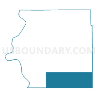
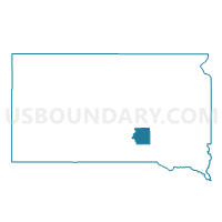
VTD precinct 4, Brule County, South Dakota
About
Outline

Summary
| Unique Area Identifier | 667061 |
| Name | VTD precinct 4 |
| County | Brule County |
| State | South Dakota |
| Area (square miles) | 106.83 |
| Land Area (square miles) | 106.51 |
| Water Area (square miles) | 0.32 |
| % of Land Area | 99.70 |
| % of Water Area | 0.30 |
| Latitude of the Internal Point | 43.53431720 |
| Longtitude of the Internal Point | -98.98105690 |
Maps

Graphs
Select a template below for downloading or customizing gragh for VTD precinct 4, Brule County, South Dakota


Neighbors
Neighoring Voting District (by Name) Neighboring Voting District on the Map
- VTD precinct 10, Charles Mix County, SD
- VTD precinct 2, Brule County, SD
- VTD precinct 5, Brule County, SD
- VTD precinct 9, Charles Mix County, SD
- VTD-precinct 3, Aurora County, SD
Top 10 Neighboring County Subdivision (by Population) Neighboring County Subdivision on the Map
- La Roche township, Charles Mix County, SD (200)
- Highland township, Brule County, SD (184)
- Torrey Lake township, Brule County, SD (180)
- Ola township, Brule County, SD (107)
- Forbes township, Charles Mix County, SD (101)
- America township, Brule County, SD (67)
- Richland township, Brule County, SD (64)
- Eagle township, Brule County, SD (54)
- Gales township, Aurora County, SD (54)
- Wilbur township, Brule County, SD (53)
Top 10 Neighboring Place (by Population) Neighboring Place on the Map
Top 10 Neighboring Unified School District (by Population) Neighboring Unified School District on the Map
- Chamberlain School District 07-1, SD (6,044)
- Platte-Geddes School District 11-5, SD (3,157)
- Kimball School District 07-2, SD (1,461)
- White Lake School District 01-3, SD (723)
Top 10 Neighboring State Legislative District Lower Chamber (by Population) Neighboring State Legislative District Lower Chamber on the Map
Top 10 Neighboring State Legislative District Upper Chamber (by Population) Neighboring State Legislative District Upper Chamber on the Map
Top 10 Neighboring 111th Congressional District (by Population) Neighboring 111th Congressional District on the Map
Top 10 Neighboring Census Tract (by Population) Neighboring Census Tract on the Map
- Census Tract 9736, Aurora County, SD (2,710)
- Census Tract 9701, Charles Mix County, SD (2,664)
- Census Tract 9731, Brule County, SD (2,657)